Hot spots of community resilience in Scotland
Published: 1 April 2019
This research builds on ongoing work around community resilience in Scotland around social and economic issues, which project team members call everyday resilience. The purpose of this research is to identify areas of Scotland that have a high resilience to threats of everyday resilience through the identification of infrastructures associated with everyday resilience.
Case Study
Hot spots of community resilience in Scotland
Elliot Meador, SRUC
Overview
Rural community resilience in Scotland is a multifaceted and complex issue that includes components of readiness and ability to respond to emergencies, long-term issues related to climate change as well as issues around population, civic and economic decline. This research builds on ongoing research around community resilience in Scotland around social and economic issues, which project team members call everyday resilience.
The purpose of this research is to identify areas of Scotland that have a high resilience to threats of everyday resilience through the identification of infrastructures associated with everyday resilience. Specifically, project team members seek to answer the following research question: What everyday resilience facilities are available to those living in rural places to aid in promoting resilient communities in Scotland; and, to what extent do emergency and everyday resilience centres exist across rural Scotland?
Methods
Researchers relied on a mixed-methods approach to data collection. Both qualitative and quantitative data collection and analysis were iterative in nature. Findings from key-informant interviews was shared with researchers working in the quantified components and discussions were had about which types of structures should be included and excluded in the database. Likewise, findings from the quantitative components were shared and discussed with researchers conducting the key-informant interviews. This process repeated throughout data collection.
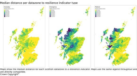
About fifteen categories of resilience types were identified by the project. Furthermore, about 16,000 different infrastructures were mapped and included in shortest-distance analysis, a GIS approach that calculates the drive-time on the road network for all places.
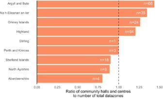
The results are shown in Figure 1. Key areas of hot spots of everyday resilience are found in Highland council and Argyll and Bute.
There are many areas in very remote rural areas of Argyll and Bute and the Western Isles that have many community development centres, a strong indication, according to key-stakeholder interviews, that there is high everyday resilience.
Findings

Figure 1: Resilience indicators by type

Figure 2: Identifying hot spots
Project outputs
The Resilience Indicators database is hosted on Zenodo.com and comes in a geopackage format that includes all files need to map the indicators and do meaningful and bespoke analysis by stakeholder groups. It is freely available to use in research dealing with resilience (or any related area). The database is aggregated at a low-level geography, and it can easily be linked with other database and models. A project report detailing the reviewed academic literature, methods and findings is available on SRUC’s website and Zenodo.com. Lastly, the code used to produce the analysis and figures is also hosted on Zenodo.com. This is freely available for stakeholders to use in their own analysis.
|
Three Key Points/Implications/Next Steps from Research |
|
Future work using the Resilience Indicators database can take advantage of the database's geopackage format -- maps and GIS analysis can easily be carried out with the database. |
|
An interesting area of study is around future climate projections and their implications on resilience. |
|
The Resilience Indicators database could be including in climate projection models to look at the future of resilience infrastructure in different climate scenarios. |
First published: 1 April 2019

